Tuesday, October 24, 2006

Winter Made its Appearance...


Two days earlier than the 05-06 season, were off. Snow made its prescence all the way down to the foothills, or about 50 miles east, and south of here. Here in the mountains, we picked up our first trace, two days earlier than last year, when it snowed on October 24, 2005. Some snow-favored areas, Such as Snowshoe, WV, and the western slopes of the allegheny mountains, 2 to 6 inch reports were common. To the south, resorts in the High Country of North Carolina, such as Sugar, and Beech resort picked up a trace.

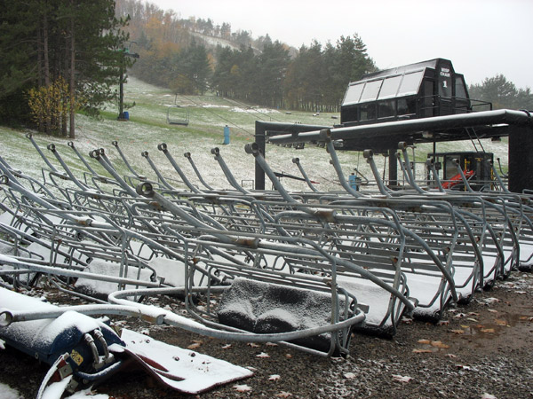
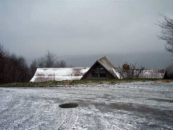
Pictures from Oct 23 at Snowshoe Mountain.
Pictures taken during event. More snow has fallen since these pictures were taken-


An article from DCski.com on the event-

Mother Nature Provides First Taste of Snow
By M. Scott Smith, DCSki Editor

October 24, 2006 — With temperatures dipping into the 20’s and teens in the mountains of the mid-Atlantic, Mother Nature provided a taste of the approaching ski season on Monday, October 23, 2006 with some light snowfall.

According to Wisp’s Lori Epp, the flurries started before dawn.
Light snow fell throughout the morning on October 23, 2006 at Maryland’s Wisp Resort. According to Wisp’s Lori Epp, the flurries started before dawn. Photo provided by Lori Epp / Wisp Resort.
The temperature at the West Virginia Resort dipped down to 17 degrees.  Snowshoe hopes to begin snowmaking by the second week of November.
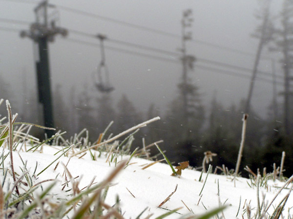
One inch of snow had fallen at Snowshoe Mountain Resort by Monday night. The temperature at the West Virginia Resort dipped down to 17 degrees. Snowshoe hopes to begin snowmaking by the second week of November. Photo provided by Andrea Smith / Snowshoe Mountain Resort.
“The flakes are big and fluffy; it is so nice to see the snow,” remarked Laura Reed of Canaan Realty.
A dusting in the Canaan Valley region of West Virginia was expected to accumulate to two inches. “The flakes are big and fluffy; it is so nice to see the snow,” remarked Laura Reed of Canaan Realty. Photo provided by Laura Reed / Canaan Realty.
Canaan Realty’s Laura Reed drove on the new section on Sunday, October 23.  “It is a beautiful stretch of road to say the least,” she said.  “One of the most scenic drives I have been on with the leaves at peak the whole way!”
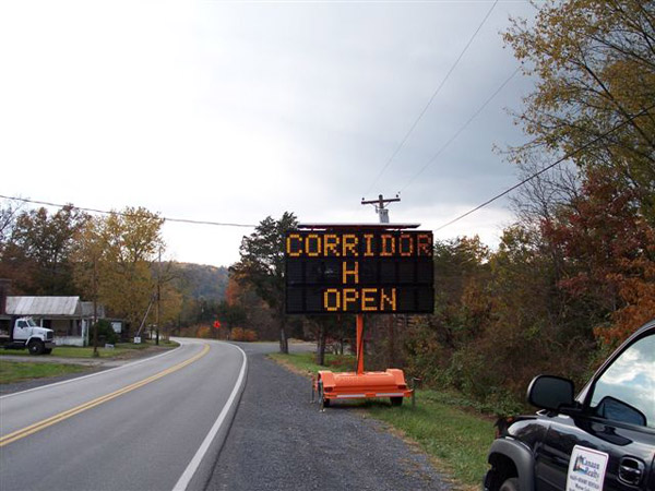
Corridor H from Wardensville to Moorefield recently opened, cutting the travel time to West Virginia resorts. Canaan Realty’s Laura Reed drove on the new section on Sunday, October 23. “It is a beautiful stretch of road to say the least,” she said. “One of the most scenic drives I have been on with the leaves at peak the whole way!” Photo provided by Laura Reed / Canaan Realty.
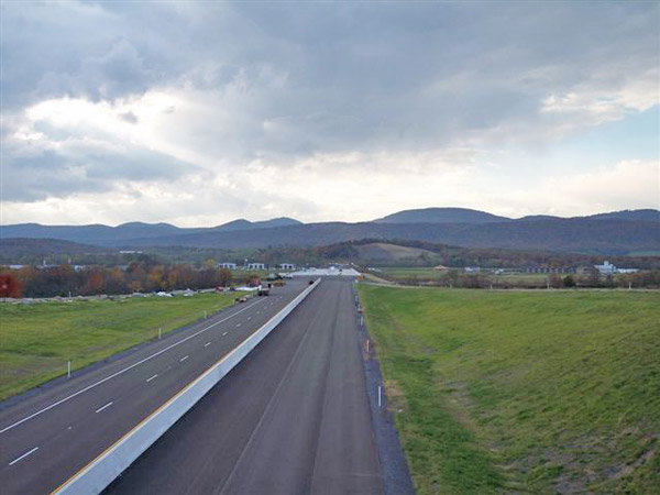
A stretch of the newly-opened Corridor H. Photo provided by Laura Reed / Canaan Realty.
__________________________________________

Snowshoe, WV - 10/24/06


__________

Ski Beech, NC Live Streaming Webcam-


___________________________________________________________________

-Currently, it is 39F, giving a 32F wetbulb. If temperatures permit, Should run the system tonight.

Saturday, October 14, 2006

We're in.

Sorry for the neglect. Here we go.

I fired up at 6:10am Friday morning. With current water temps around 50F, ground temps way to warm, and the relatively high temp (For snowmaking standards, a Wetbulb of 25 is high), I did not get very much out of it, but I expected that. As the water temps cool off, Will be able to make the 3-5' mounds the system is capable of.

Friday morning pictures-


Friday, October 13, 2006

Ahh Yes.

Have not updated for quite some time now, and it is hard to type with frozen fingers. But that cold shot I mentiond in a previous post has delivered, while not int the form of snow, but in cold temps. Currently here it is 26F, with light winds. Awesome for some October snowmaking. At 6:10am, I set out the ground gun. To my delight, a white substance began to accumulate.


Plan to run until around 8am.


But yes, Another trip to snowshoe happening this afternoon, and snowmaking this morning. Awesome Friday the 13th.

Saturday, October 07, 2006

Next Week...
Computer models are trenduing cooler, and a freeze, even outside of the higher elevations, may occur next week. Last night, we bottomed at 38. Snowshoe, WV officially picked up a trace of snow overnight, making it the first accumulating snow of the season. A poster at EasternUsWx reported, and posted pictures of snow in highland county, Less than an hour North of here.
If temperatures permit, the first snowmaking may occur here, as well as many resorts in the East. although it is 7 days out, the NWS in Blacksburg has already projected a Friday high of 49.
As far as local pictures, I am heading to Warm Springs Mtn as soon as I get off of work, so hopefully will be able to grab some nice shots and video clips. Even if it isnt snow, the foliage is peaking across the higher elevations.

Friday, October 06, 2006

Needs no title


This will work


SHORT TERM FORECAST
NATIONAL WEATHER SERVICE CHARLESTON WV
902 PM EDT FRI OCT 6 2006

WVZ046-070415-
POCAHONTAS-
INCLUDING THE CITY OF...MARLINTON
902 PM EDT FRI OCT 6 2006

9 PM TO 3 AM...CLOUDY. RAIN AND SNOW LIKELY UNTIL MIDNIGHT...THEN
A CHANCE OF RAIN MIDNIGHT THROUGH 3 AM. LITTLE OR NO SNOW
ACCUMULATION. COLD WITH LOWS IN THE UPPER 30S. LIGHT AND VARIABLE
WINDS. CHANCE OF PRECIPITATION 70 PERCENT.
3 AM TO 9 AM...MOSTLY CLOUDY. A SLIGHT CHANCE OF RAIN THROUGH
6 AM. LIGHT AND VARIABLE WINDS...BECOMING NORTHEAST AROUND 10 MPH
WITH GUSTS UP TO 30 MPH THROUGH 9 AM. CHANCE OF RAIN 20 PERCENT.

Noreaster?

Hardly. But still, the low pressure cutoff is making things interesting. Currently here, it is 42 degrees, with light rain. Reports in from locals, and snow enthusiasts like myself, that it is indeed snowing at and above 3500' or so. A forecast low of 39 here at 2000'. Any slight change for the cooler may result in a change in P-type. Hope. Chilly enough here that a fire may be needed.


KHSP (3900') is reporting 38 and rain. Right at the edge of a changeover.


Snowshoe, WV-

Tonight: Periods of rain and snow before 4am, then a slight chance of rain. Low around 33. Northeast wind between 5 and 7 mph, with gusts as high as 21 mph. Chance of precipitation is 80%.


Saturday: A slight chance of showers after 11am. Mostly cloudy, with a high near 49. East wind 15 to 18 mph decreasing to between 6 and 9 mph. Winds could gust as high as 31 mph. Chance of precipitation is 20%.


And a CRW (Charleston, WV) discussion-


AREA FORECAST DISCUSSION
NATIONAL WEATHER SERVICE CHARLESTON WV
743 PM EDT FRI OCT 6 2006


.AVIATION...


AT 22Z UPPER LOW APPEARS SE OF LYH. COOLEST LOW LEVELS ARE NOW
THRU ABOUT 05Z. RAIN/SNOW LEVEL DOWN TO ABOUT 3000 FEET MSL EKN-
BKW CORRIDOR DURING THAT INTERVAL...BEFORE WARMING.


So thats about as much as I can dig up as far as conditions here in the mountains go.
Hopefully something noteworthy will come up in the next few hours...

Monday, October 02, 2006

Yeah its Fall

And 76 degrees, with a high of 82. Near freezing a few nights ago. Its fall.

As far as the voyage to snowshoe goes- So close, but no... snow. Managed 41 and Rain up at 4848'. But it was a really nice feeling, and reports of flurries from the locals that morning made it even better. Unfortunately, we couldnt make out any pictures, as the sun was nearly gone when we arrived.

But it is October now. If this were 2005, many of us in the East would be on the snow in 24 days. (If in case you dont remember, Remanants of Wilma dropped as little as a trace on the NC high country, 10" on Snowshoe, WV, to as much as nearly 4 feet in Vermont and New Hampshire.)

This is October. Anything can happen.

Yeah its Fall.